Special Edition Final Report Nov. 9, 2001
_____________________________________________________________________________________
The Fort Edwards Archaeologist
_____________________________________________________________________________________
Report on the Archaeological Excavations at Fort Edwards, home site of Joseph
Edwards and a French and Indian War frontier fort of Col. George Washington.This archaeological excavation is part of the ongoing project of The Fort Edwards Foundation of Capon Bridge, West Virginia, to preserve, protect and interpret the home site and fort site at Joseph Edwards's land grant on the banks of the Cacapon River in Hampshire County, West Virginia. This site represents both an early settler's home of the second quarter of the eighteenth century and a French and Indian War fort in Col. George Washington's chain of forts protecting the Virginia frontier. The excavation is under the direction of Dr. Stephen McBride of Wilbur Smith Associates of Lexington, KY. This page is one of a series of reports on the work.
___________________________________________________________________________________
Final Report Summary
Excerpts from: "For the Protection of Your Lives and Fortunes...",
Archaeological Explorations at Fort Edwards,
Hampshire County, West Virginia.
by W. Stephen McBride
Submitted by Wilbur Smith Associates
to The Fort Edwards Foundation
November 2001
Chapter One: Introduction
In May 2001 archaeologist from Wilbur Smith Associates conducted exploratory archaeology at the site of Fort Edwards (46Hm75), Capon Bridge, West Virginia for the Fort Edwards Foundation, Inc. Fort Edwards was an important French and Indian War fortification as well as an eighteenth to twentieth century farmstead. During the French and Indian War, it was one of a chain of forts that spanned the entire length of what was then western Virginia. These forts were built to maintain the western boundary of settlement by providing military posts and places of refuge for settles. The idea was not only to defend these settlements but also to give the settlers enough confidence to stay. If these settlements crumbled it would open up the older, more established settlements to Indian incursions.
Overall, Fort Edwards and the other forts in the chain did help successfully defend and maintain the frontier boundary. They also served a number of other political, economic and social functions. Fort Edwards, for instance, played a critical role in the transportation of goods and troops by providing protection and a refuge for convoys traveling on the road between Winchester (Col. George Washington's headquarters) and Fort Cumberland.
Although there is a moderate amount of documentation on these forts, there are no detailed period descriptions or maps of the Virginia French and Indian War forts. We do not know exactly what they looked like, what kind of buildings they contained, or what range of activities took place within them. Archaeology is the best method for investigating these gaps in our knowledge.
The 2001 archaeological excavations of Ford Edwards described here were directed toward discovering more about the layout and material culture of this fort site and through this to begin to construct a picture of what at least one of these forts looked like. The discoveries made at Ford Edwards in 2001, while still preliminary, provide us with the most complete physical information on any French and Indian War fort in the Virginias.
The report to follow will describe the results of this archaeological investigation including the test units and trenches excavated, stratigraphy of the site, cultural features encountered, and artifacts found. Before the archaeological results are discussed in Chapter 3, the previous archaeological investigations at Fort Edwards and our 2001 field and laboratory methods will be summarized in the remainder of this chapter. A brief history of the site will also be present in Chapter 2. This history will provide the reader with the necessary context to understand the significance of the archaeological discoveries and interpretations. The final chapter will consist of a summary and conclusions of the 2001 investigations as well as recommendations for future research. [p. 1.1]
Archaeological Goals and Methods
The goals of the Fort Edwards archaeology were twofold. The first goal was simple and explicit; locate evidence of the colonial period, and more particularly the French and Indian War period occupation of the site. This evidence could include period artifacts as well as subsurface features or soil strata which date from the 1740s to 1770s. Obviously, the most desired feature would be evidence of the fort's stockade in the form of a trench with posts. One segment of this stockade had been discovered in 1990 by Gardner (1990) and it was hoped that more of the stockade would be discovered in this excavation. While Gardner's discovery verified this site as the location of Fort Edwards it did not determine the size and shape of the fort. We hoped that the 2001 investigation would help us to begin to understand the layout of this fort and activity areas associated with it.
The second goal of this project was to assess the archaeological integrity and chronology of the site.
In other words, what time periods do the artifacts and features on the site date from, does this vary from one part of the site to the next, and are the artifacts from features and soil strata in association with temporally similar artifacts or are they mixed with artifacts from different eras? If artifacts from one context are only associated with temporally similar artifacts, the deposit or context [p. 1.3]
has high integrity. Archaeologists can do more detailed analysis with high integrity deposits because they can assume that they were created over a relatively short period of time... In other words these high integrity contexts are "time-capsules of the past."Another part of the second goal was to work toward dating the double house standing at present on the site.
In order to meet the above goals we devised a multi-stage approach. We began this investigation by having the western yard plowed and disked to prepare it for surface collecting... Our surface investigation was directed at locating eighteenth century artifacts, mapping them in, and then determining if they were found in association with later artifacts. The mapping was completed by pin-pointing or "piece plotting" each eighteenth century artifact (or possible eighteenth century artifacts) with a total station instrument and prism stadia.
The second stage of our investigation was the excavation of small excavation pits, called shovel test probes (stps) at an interval of 5 to 10 meters across the site...
The third stage of investigation involved the excavation of larger test units. Four I x I m test units were excavated in areas where concentrations of middle eighteenth century artifacts were recovered in the stps or on the surface...
Through the excavation of the larger test units we hoped to both get a better look at the soil stratigraphy and increase the quantity of artifacts recovered. A larger assemblage of artifacts would help us better date the different soil strata and better understand the past activities which led to the deposition of artifacts in a given area.
The final stage of archaeological investigation at Fort Edwards consisted of some hand soil stripping and the mechanical excavation of trenches across the western, southern and northern yard areas. The hand stripping consisted of removing the plowzone overlying part of the stockade trench exposed by Gardner in 1990. This was done to clearly locate this feature before backhoe work [p. 1.5]
started. A backhoe with a 36 inch bucket was then utilized to excavate the trenches. The purpose of these trenches was specifically to discover subsurface evidence of the fort's stockade and more generally to discover the nature and density of subsurface features in the western, southern and northern areas of the site...We conducted the backhoe investigation by excavating roughly 36 inches wide trenches down to subsoil with at least one archaeologist monitoring. If any stain resembling a feature was encountered, the archaeologist would stop the backhoe and expose the stain with hand tools (shovel and trowel). If the stain was thought to be a cultural feature it was flagged and the backhoe moved beyond it to continue excavation. The trenches were excavated parallel to each other at an angle roughly 45 degrees from the orientation of the 1990 stockade...
When a trench was excavated additional archaeologists would carefully trowel, expose, and map all features discovered in that trench. Map construction consisted of both taking measurements and drawing a map on graph paper as well as recording the edges of each feature with the total station transit....
Surface Collecting and Metal Detecting
...A large variety of colonial period, or possible colonial period, artifacts were collected from the western and northern yard areas. These artifacts included delftware, white salt-glazed stoneware, creamware, pearlware, slipped and glazed redware, British and German Stoneware and weathered green bottle glass.
These artifacts certainly confirm that this site was occupied in the middle and late eighteenth century and that the western and northern yards were centers of activity during this period. No great concentrations of colonial period artifacts were noted however, although there were more just west of the present house. Most of these artifacts were redware, creamware and pearlware, however, which could date as late as early nineteenth century. Very few likely middle eighteenth century ceramics, such as delftware and white salt-glazed stoneware were recovered.
A large number of nineteenth century and twentieth century artifacts were also recovered from the western yard. These artifacts included whiteware, bottle glass and various metal items. The presence of these later artifacts supports a long occupation for the site and strongly suggests that the western yard does not have much temporal integrity within the plowzone or topsoil... The metal detection survey conducted away from the high density western or northern yards did not produce any artifacts other than a few modern farm related items. We therefore, did not locate any discrete eighteenth century activity areas away from the house site.
Additional metal detecting was conducted in the closer western yard following the broader survey. Not surprisingly, this closer detecting uncovered much metal, mostly nineteenth or twentieth century...
Artifacts [from STPs]
...Artifacts from the shovel test probes suggest a date range of the middle eighteenth century through the twentieth century for this site and strongly suggest some changes in the use of space over time.
Artifacts from the middle eighteenth century include delftware, Whieldonware (Clouded-ware), white salt-glazed stoneware, Jackfield, and slipped redware (Figure 3.6). Late eighteenth to early nineteenth century artifacts include creamware, pearlware, and many of the lead glazed redware sherds. Other probable eighteenth century artifacts include wrought nails, gunflints, pewter buttons, kaolin pipe fragments, and heavily petinaed dark green bottle glass (Figure 3.6). Middle to late nineteenth century artifacts include painted, sponged, shell edged and transfer printed [p. 3.10] whiteware, hand and fused applied bottle lips, and late cut nails. Twentieth century artifacts include machine-made bottle glass, wire nails, aluminum foil, ammunition cartridges, pull tabs, and plastic. While artifacts reflect the entire occupation span of the site, they also point out the complexity of investigating a site with such a long occupation....
Artifacts [from Test Units]
The artifacts recovered from Units 1-4 are listed by zone in Table 3.2. As can be seen in this table, all of these units produced a significant amount of artifacts. Unit 1 produced a tremendous assemblage of nails and also many dining/kitchen artifacts. Units 3 and 4 were extremely productive, particularly with animal bone, daub and redware. But, what is most exciting and important about these units is the great temporal integrity of the soil strata, particularly in the lowest zone or zones whose artifacts date exclusively from the eighteenth century. The artifacts from these strata offer tremendous potential for examining life at Fort Edwards during the middle eighteenth century. [p. 3.34]
Stockade Trenches and Bastion
The most exciting features discovered by far were the stockade segments and of these, the bastion was certainly the most significant...
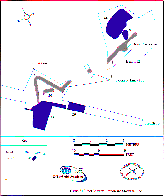
The most exciting section of stockade trench discovered resulted from the exposure of a small section of possible stockade trench in Trench 10. This section was chased to the northeast where it extended for 3 m and then turned abruptly to the southeast. It continued at this orientation for 3.5 m and then turned to the west. We quickly realized that we had discovered a bastion within one wall of the stockade (Figures 3.39 and 3.40). A dark curved stain (Feature 56) was also exposed inside the bastion. The function of this feature is unknown but it may be related to a platform support for the bastion. We then backhoed more to the east and exposed 20 m more of the stockade trench (Feature 39). The feature fill upon exposure was nearly black, but became more mottled toward the east. Again this stockade trench came to an abrupt end. Why it ended is unclear but it likely abutted a building or the stockade construction method changed. More excavation is necessary to determine which, if either, of these explanations is correct. [p. 3.54]
The discovery of the "V" shaped bastion was very exciting and contributes significantly to our understanding of variability in frontier fort design. Before this discovery diamond or ovalshaped corner bastions had been found on Virginia and West Virginia frontier forts (Neiman 1986; M cBride and McBride 1998). The "V" bastions generally occur in the middle of the stockade wall rather than in the corners. Bastions of this type were built at Fort Allen, Pennsylvania in 1756 and at Hannastown, Pennsylvania (Waddell and Bomberger 1996:32). The symmetrical shape of the Fort Edwards bastion, and the angle at which the bastion intersects with the main stockade (curtain) wall suggests that this was a center wall bastion rather than a corner "half-bastion" like that found at Fort Allen. Unfortunately, the presence of a cellar feature (Feature 58) at the southwestern end of the bastion makes it difficult to determine where the stockade went to the west. The position of this bastion led us to re-examine Features 52 and 49 in Trenches 9 and 8, respectively, and Feature 13 in Unit 1. It is possible that these features, particularly Features 13 and 49. were stockade trench features also...
The 2001 archaeological investigations have made significant strides toward understanding the nature of the Fort Edwards' fortification. Indeed, the Fort Edwards's stockade is the best preserved and most extensively exposed of any Virginia or West Virginia French and Indian War fort. The discovery of the more easterly segments of the stockade trench (Features 39 and 40) were especially exciting and have allowed us to begin a visual understanding of the fort's size and layout... [p. 3.59]
At present, For Edwards appears to have had both academic features, such as the "V" bastion, and vernacular features, such as the irregular configuration of the southwestern stockade trenches. The combination of both types of features is quite fascinating and is very reflective of the culture and conditions under which the fort was built. As a fort probably built not by Washington's Virginia Regiment, but by local settlers, Fort Edwards has tremendous potential for providing insights into frontier culture and military ideas. But as a fort later occupied, and perhaps improved, by the Virginia Regiment, Fort Edwards also offers a great opportunity to investigate more official military life during the French and Indian War. It truly offers the best of both worlds and unlimited research potential. [p. 3.61]
Other Features
A number of additional features, including post molds, pits and cellars were discovered during the backhoe trenching at Fort Edwards...
Backhoe trenches 7-10 produced a greater variety and number of features than were found in the more southernly trenches. These features include five cellars, seven pits, six post molds, and five unknown or unclassified features.
Two burned areas, were discovered while chasing the eastern end of the stockade trench. Three of the five cellars were about two meters (roughly 6 ft) long and covered the entire backhoe trench width (60 cm or 3 ft). These small cellars fit the size of typical [p. 3.61]
underground root cellars which were used to store food products and were usually, but not always, under buildings...Two other cellars were much larger. Feature 53 was over five meters (about 16 ft) long while Feature 58 was over four meters (about 12 ft) long and at least four meters wide. These size cellars fall within the category of a basement and suggest that substantial buildings, either houses or kitchens, were present over these two features. The quantity of domestic refuse recovered in the shovel test probes in this area also supports the presence of domestic buildings in this area.
[Present structure]
No builder's trench was visible adjacent to the frame addition foundation. At this point at least, the foundation stones were pushed to the edge of the builder's trench,so there was nothing to [p. 3.67]
further excavate here. At the log house however, a possible builder's trench (Feature 62) was found adjacent to its foundation (Figures 3.51 and 3.52). Excavation into this feature, however, showed it to be rather shallow (30 cm) for a builder's trench and heavily contaminated with styrofoam and aluminum foil as well as earlier artifacts. The looseness of the soil and the modern artifacts suggest rodent activities along the foundation wall. Our attempts to date a builder's trench at these buildings was therefore, unsuccessful.To summarize, the backhoe and hand trenching phase of investigation was very successful in locating subsurface features, particularly the stockade trench, as well as cellars, pits and post molds... The placement of a "V" shaped bastion along the northern wall suggests some knowledge of classical military design theory. While the eastern part of the fort appears to have been rectangular with one or more bastions, the southwestern section of the fort seems rather irregular with two north-south running walls, Features 7 and 26.
...Another, perhaps earlier, house was likely located at Feature 53 or 58. The presence of Feature 6, found by Gardner (1990) and Feature 8 in the southern half of the site suggests eighteenth century domestic activity in this area as well. The large gunflint found in Feature 8 may point to military occupation of the southern part of this site as well. There seems to be two to three loci of eighteenth century activity on the site and only through more excavation can we better determine their date ranges and association with civilian or military occupations. [p. 3.70]
Conclusion:
The 2001 excavations demonstrated that the Fort Edwards site is well preserved and has tremendous potential for providing critical new information on French and Indian War fortifications and frontier life. It has the best preserved middle eighteenth century cultural features and refuse middens ever found in West Virginia or Western Virginia. The degree of stratigraphic integrity and the quantity and variety of features discovered exceeded expectations and indicate that the site has great research and interpretive potential.
The most exciting feature found was certainly the fort bastion... This feature, along with the other stockade trench segments discovered, provide the most complete physical evidence of a French and Indian War fort ever found in the Virginias. Although more excavation is needed to fully understand this fort, what we have uncovered suggests that it was in the range of 175 ft by 85 ft in size and that there was an academic element, evidenced by the bastion, in its design. The large number of cellars discovered may reflect on the density of buildings within the fort, but more excavation is needed to determine which cellars are contemporaneous with the fort.
All of the archaeological methods employed, with the possible exception of metal detecting, were successful in completing the twin goals of the project: locating the colonial era deposits and accessing the archaeological integrity of the site. The excavation of shovel test probes (stps) was especially successful in helping understand the site spatially, especially where the earliest and most intact artifact deposits were located.... The lowest strata dated from the eighteenth century and appeared to be undisturbed. The stps also demonstrated that the western and southern portions of the site did not have good integrity outside of features. These areas of the site had been plowed to a depth that mixed-up all cultural material above the subsoil. Subsurface features were located in these areas, however....
The backhoe trenching resulted in the discovery of 53 cultural features... Most significantly, three new segments of stockade trench were discovered which added significantly to our understanding of the size and layout of the fort. Other features found include large and small cellars, probable trash or refuse pits and a number of post molds. Although we only had time to test a few of these features, a number of these, including both cellars and trash pits, appear to date from the middle and late eighteenth century.
The combination of well preserved features and stratigraphic deposits truly make Fort Edwards a unique time capsule of eighteenth century frontier lifeways. Its history as a fort and a frontier farmstead allows us to examine both pioneer adaptations and military culture in a time of international conflict. [pp.4.1-4.2]
Acknowledgments
Funding for this project was provided by the Fort Edwards Foundation, Inc. Thanks to all its members and especially Charles Hall, David Pancake and Ken Edmunds for their support, patience and background information. Charles is especially thanked for providing logistical and moral support, organizing volunteers and creating the educational web site. Foundation members Roberta and Dick Munske opened up their home to us "grubby" archaeologists and made us feel truly at home. Much thanks.
The project was fortunate in generating much interest and some of this translated in providing us with a large number of volunteers. Many thanks go out to dig volunteers: Greg Adamson, Megan Angebine, Ruth Berkeridge, Janice Biller, Charlotte Brewster, Jim Cawley, Julie Flanagan, Ginny Householder, Don Judy, Greg Kenney, Jim Lancia, Mark Lore, John McKee, Becky Moore, Carole Nash, Buck O'Brien, Nancy Pfaff, Isabel Plowright, Mike and Judy Rose, Mary Sears, Becky Szabo, Kay Veith, Mable Voit, Jake Wysopal, and Kim McBride. Thanks also to school program and public tour organizers and guides Bob and Julie Flanagan, Charles Hall, Jean Kesner, Roberta Munske and Charlie Parker. Ray Schmidt is thanked for providing video footage of the excavations.
To my crew and to the other support staff at Wilbur Smith Associates I also owe a big thanks. Kurt Rademaker served as crew chief and land surveyor, while Cathy Karnes and Keith Heinrich served as the crew. Jim Fenton also assisted in the field. Susan Andrews catalogued and analyzed the artifacts and she and Robert Ball assisted with report preparation and production. Howard Beverly produced the artifact distribution maps, Lenny Taylor drafted the unit plans and profiles and Richard Wright produced the site maps.
Please note: This is a very brief condensation of the report. It is intended simply to give our members and friends a sense of the success of our archaeolgoical work and the importance and uniqueness of our site. The Fort Edwards Foundation may publish a condensation of this report and make it available to the public. However, due to the press of other business, this report may not be available until our Visitor Center opens for the summer season in June 2002.
We appreciate your continued interest and support. Please note that we are in need of volunteers for our school program this year and for our docent program for next summer.
The Fort Edwards Foundation
